|
The Domesday book was commissioned in December 1085 by
William the Conqueror,
who invaded England in 1066. The first draft was
completed in August 1086 and contained records for 13,418 settlements in
the English counties south of the rivers Ribble and Tees (the border
with Scotland at the time).
The survey was conducted upon William's instructions approximately 20
years after the invasion. The Saxon Chronicle records that it took place
in 1085, whilst other sources claim 1086. In either event it forms a
remarkable written record of the state of the nation so soon after the
invasion. The whole exercise was conducted in less than a year and is
now held in the Public Record Office.
One of the regional versions, from
Ely Abbey, tells us what the Commissioners were to ask. These questions
appear to form the basis for the whole survey and were:
 How many
hides? How many
ploughs, both those in lordship and the
men's? How many villagers, cottagers and
slaves, how many
freed men and
Freemen? How much woodland, meadow and pasture? How many
mills and
fishponds? How much has been added or taken away? What the total was and
is? How much each free man or Freeman had or has? All threefold, before
1066, when King William gave it, and now; and if more can be had than at
present?
It was called the Domesday Book by the landowners because it was the
final authoritative register of rightful possession in the land, by
analogy its judgement was as final as that of Domesday. Each manor is
listed with it's owner, with other details and in particular relates
values of those manors before, during, and after the invasion.
  The Domesday survey was far more than just a physical
record, it was a detailed statement of lands held by the king and his
tenants and of the resources that went with those lands. It recorded
which manors rightfully belonged to which estates, thus ending years of
confusion resulting from the gradual and sometimes violent dispossession
of the Anglo-Saxons by their Norman conquerors. It was moreover a
'feudal' statement, giving the identities of the tenants-in-chief
(landholders) who held their lands directly from the Crown, and of their
tenants and under tenants. The Domesday survey was far more than just a physical
record, it was a detailed statement of lands held by the king and his
tenants and of the resources that went with those lands. It recorded
which manors rightfully belonged to which estates, thus ending years of
confusion resulting from the gradual and sometimes violent dispossession
of the Anglo-Saxons by their Norman conquerors. It was moreover a
'feudal' statement, giving the identities of the tenants-in-chief
(landholders) who held their lands directly from the Crown, and of their
tenants and under tenants.
Scroll to bottom of page for Glossary |
The Manor of Winsham
The Manor of Winsham, which
was 10 hides (1200
acres), was held
by the Canons of Wells Cathedral in Saxon times. It was seized briefly
by Harold II but reverted back to the Canons after the conquest.
Winsham
was mentioned in Domesday Book as Winesham meaning 'Wyna's
settlement' from the Old English wynes and ham.
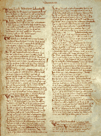
The entry in Domesday for Winsham reads :-
Osmund holds WINSHAM from the Bishop. Alfsi
held it before 1066; it paid tax for 10 hides. Land for 16
ploughs,
of which 4 hides are in lordship; 3 ploughs
there; 12 slaves;
50 villagers with 9 ploughs & 6 hides. 1 pigman who pays 12 pigs.
2 mills which pay 20s; meadow, 6 acres ; woodland ˝
league
long and 1˝ furlongs wide. 2 cobs; 15 cattle;
13 pigs; 270 sheep.
The value was Ł6; now Ł10
Also at the time of Domesday two Barons,
William
de Mohun and William d'Eu, were
Tenants in
Chief holding lands in parts of what is now Winsham parish.
William de Mohun
Bringing many knights and men-at-arms to the Battle of
Hastings, William de Mohun (Moyon) held 55 lordships in Somerset, with
his seat at Dunster Castle. His grandson, William would become the first
Earl of Somerset. William was from Moion near St.Lo in Normandy.
Lands he held in Somerset included :- Adsborough,
Alcombe, Aley, Allercott, Avill, Bickham, Bishop's Lydeard, Bratton,
Brewham, Broadwood, Brompton Ralph, Broomfield, Brown, Cheriton,
Chubworthy, Clatworthy, Combe Sydenham, Cutcombe, Dunster, East Lydeard,
Elworthy, Hartrow, Heathfield, Holford St.Mary, Holnicote, Kilton,
Knowle, Langham, Leigh(Milverton), Leigh (Winsham), Luxborough,
Minehead, Newton (Bicknoller), Nunney, Oatrow, Old Stowey, Poleshill,
Quarme, Runnington, Shotmansford, Staunton, Stocklinch, Stoke sub Hamdon,
Street, Tolland, Torweston, Westowe, West Quantoxhead, Willett, Woolston,
William d'Eu
Lands held by William d'Eu in Somerset
included :- Chilton Cantelo, Hinton Blewett, Hinton St. George, Laverton,
Tickenham, Whatley (Winsham), Yeovilton.
Glossary
Acre
- Measurement of land used in Domesday mainly for pasture,
meadowland and woodland, which varied from region to region.
Carucate -
Measurement of land in Danish counties, the equivalent of a hide. Used
in Domesday for tax purposes.
Freedman - A former slave, now of similar status to the lower
class of peasant.
Freeman (liber
homo and sochemann)
- The two Latin terms have similar
meanings; a villager of higher class than a villanus, with more land and
obligations; a soke man, for example, was liable to attend the court of
his soke.
Furlong
- A quarter of a virgate, or a measure of length, originally Roman;
commonly 220 yards, similar to the modern furlong used in horse racing.
Hide
- 120 acres, although this could vary, and sometimes was apparently
around 240 acres. Domesday hide values were not real measurements
of land, but figures on which tax (geld) was based.
League
- Three miles.
Lordship
- Land held and farmed by the tenant-in-chief himself, or by the
under-tenant himself (or herself).
Mill
- A watermill. There were no windmills in England for another 100 years.
Plough
- In Domesday the word implies a plough team with its eight oxen
and the plough itself. The measure of a carucate was originally the
amount of land which such a team could plough in one day.
Slave
- A man or woman who owed personal service to another, and who was
un-free, and unable to move home or work or change allegiance, to buy or
to sell, without permission.
|