Farming methods had not altered very much for hundreds of years, but towards the end of the nineteenth
century, with the advent of steam, and the early part of the twentieth century,
with the development of the internal combustion engine, things did begin to
change.
First the big steam driven traction engines were used for powering such things as threshing machines, and transporting large loads. As the twentieth century moved into its second and third decades, the smaller and more versatile petrol driven tractor began to make its presence felt, although many of the lighter tasks continued to be carried out by hand.
Despite this, the use of the land for agriculture had always been
governed by a number of factors, and these continued to be as relevant
as ever The soil, the aspect, the ownership, the markets and the
subsequent adaptability of crops and livestock. (Click on small maps to
enlarge).
|
|
SOIL
In this hilly Parish the existing top soils were laid down at the end of the last ice age (10,000 yrs ago). These are the 'clay and flints' overlying the Chalk ( mostly above 600 ft ) , the Upper Greensand (mostly above 400ft) and the Jurassic sands and gravels right down to the Axe River. The soil acidity is usually above neutral (6.7ph). Within this general distribution, even within fields, the top soil varies.
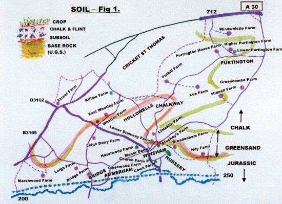 For example, in the top four-acre comer of the last field before the Winsham road junction with the A30 main road there was a Gorze dividing-hedge and Bracken grew in profusion along the other
hedges, providing signs of acidity (over chalk at depth).
Further along that same field, all the stones are rounded like a pebble beach (at 773ft) . Other Parish fields display dark loams, sands or in one case, peat. A soil sample of 14 fields on one farm shortly after the War showed no two exactly alike. Few Winsham fields are flat. The Rothamsted Experimental Station
'generalised soil map (1974)' denotes the Winsham area soils as 'Palio-argillic Brown Earths and Stagnolley Soils'. The soils of Winsham are rated 'grade 3'. There are some 'Grade 1' Somerset soils to the north said to be 11 ft thick of loam. These grow potatoes and other market garden crops. For example, in the top four-acre comer of the last field before the Winsham road junction with the A30 main road there was a Gorze dividing-hedge and Bracken grew in profusion along the other
hedges, providing signs of acidity (over chalk at depth).
Further along that same field, all the stones are rounded like a pebble beach (at 773ft) . Other Parish fields display dark loams, sands or in one case, peat. A soil sample of 14 fields on one farm shortly after the War showed no two exactly alike. Few Winsham fields are flat. The Rothamsted Experimental Station
'generalised soil map (1974)' denotes the Winsham area soils as 'Palio-argillic Brown Earths and Stagnolley Soils'. The soils of Winsham are rated 'grade 3'. There are some 'Grade 1' Somerset soils to the north said to be 11 ft thick of loam. These grow potatoes and other market garden crops.
|
|
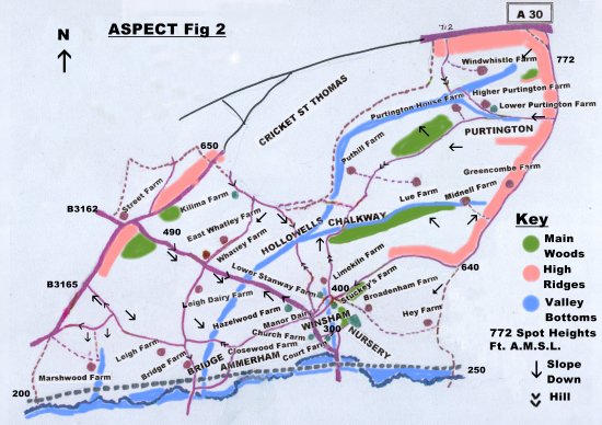
ASPECT
Winsham is tilted towards the south-west from the Windwhistle Ridge (772ft) down to the River Axe (200ft) and is only 7 miles due North from the sea at Charmouth.
 This leads to a mild climate. The clay from the chalk (blue and yellow) and the clay (gault) below the greensand (a good aquifer) leads to plenty of spring water. There are also 'sinks' into the base rock. The reputed rainfall grades from of about 37 to 29 inches from top to bottom of the hills. The prevailing wind is S.W. This leads to a mild climate. The clay from the chalk (blue and yellow) and the clay (gault) below the greensand (a good aquifer) leads to plenty of spring water. There are also 'sinks' into the base rock. The reputed rainfall grades from of about 37 to 29 inches from top to bottom of the hills. The prevailing wind is S.W.
|
|